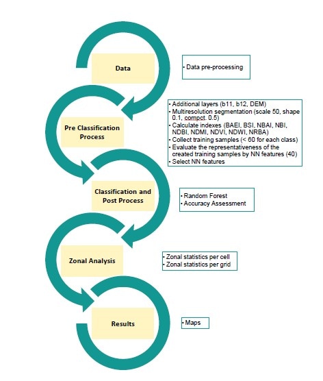
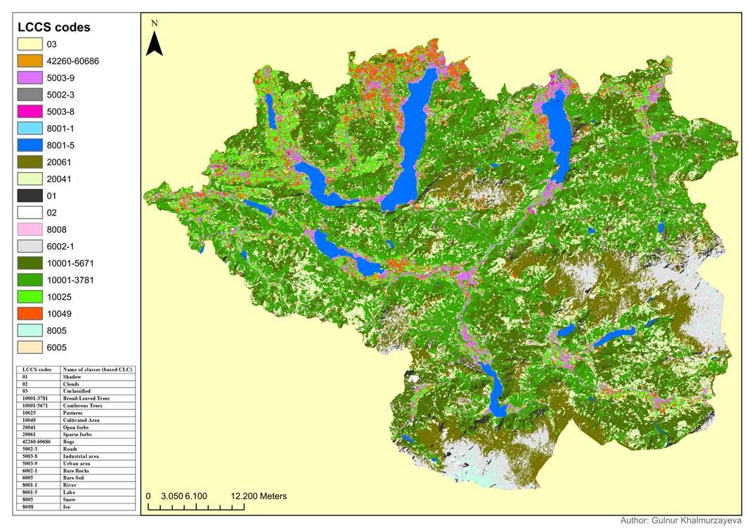
Abstract Nowadays, every month/year changes occur on the surface of the Earth from a small build ups till large-scale natural disasters that destroyed entire settlements. Observation and analysis using satellite data can help to improve and prevent any natural or anthropogenic disaster, plan and calculate beneficial usage of the land cover. Remote Sensing and Spatial Analysis tools are one of the approaches for them. The aim of this thesis is to perform zonal operators and report categorical data using the European Terrestrial Reference Frame (ETRF) grid. This study tries to sustain its one of the advantageous approaches for extracting information from automatic mapping. For that Sentinel-2a (S2) optical data for Land Cover Classification System (LCCS) classification and regular grids with 100 m, 1 km spatial resolution for zonal statistics were used. First of all, object-based image classification with random forest classification techniques using LCCS classes was done with an accuracy of 88%. After, using the classification data, the variety and the majority of classes per grid cell were extracted as well as area of classes and number of objects per grid was aggregated by zonal operators within regular grid. Moreover as a study area, Salzkammergut was chosen, historical and recreational area part of Austria, which consists of 52 districts from three federal states and has no an official administrative boundaries. Nowadays, every month/year changes occur on the surface of the Earth from a small build ups till large-scale natural disasters that destroyed entire settlements. Observation and analysis using satellite data can help to improve and prevent any natural or anthropogenic disaster, plan and calculate beneficial usage of the land cover. Remote Sensing and Spatial Analysis tools are one of the approaches for them. The aim of this thesis is to perform zonal operators and report categorical data using the European Terrestrial Reference Frame (ETRF) grid. This study tries to sustain its one of the advantageous approaches for extracting information from automatic mapping. For that Sentinel-2a (S2) optical data for Land Cover Classification System (LCCS) classification and regular grids with 100 m, 1 km spatial resolution for zonal statistics were used. First of all, object-based image classification with random forest classification techniques using LCCS classes was done with an accuracy of 88%. After, using the classification data, the variety and the majority of classes per grid cell were extracted as well as area of classes and number of objects per grid was aggregated by zonal operators within regular grid. Moreover as a study area, Salzkammergut was chosen, historical and recreational area part of Austria, which consists of 52 districts from three federal states and has no an official administrative boundaries.